Mion Desekyere
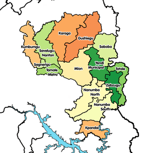
Mion Desekyere e la a desekyere pie ane ayoɔbo na kaŋa naŋ be a Northern Irigyiŋ poɔ, Ghana.[1][2][3] O da daŋ paale la a Yendi Desekyere kpoŋ na poɔ 1988 eŋɛ, naŋ da kuri yi a East Dagomba Desekyere Kansil koroo poɔ, te ta saŋa na a desekyere western sɛŋ naŋ da wa wɛle na kuri Mion Desekyere 28 Gyoone 2012 eŋɛ; kyɛ ka o kyɛlee na naŋ taa o yomeŋɛ na, naŋ leɛ Yendi Munisipal Desekyere (naŋ da zɛge do are munisipal desekyere asɛmbole vo-araa 29 Fɛboɔre 2008). A desekyere asɛmbole bezie be la a Northern Irigyiŋ central sɛŋ, a taa Sang ka o e o teŋkpoŋ.
| Inception | 28 Gyoone 2012 |
|---|---|
| Paaloŋ | Ghana |
| Kapital/teŋkpoŋ | Sang |
| Located in the administrative territorial entity | Northern Region |
| Located in time zone | Greenwich Mean Time |
| Coordinate location | 9°25′2″N 0°16′43″W |
| Office held by head of government | District Chief Executive |
| Shares border with | Yendi Munisipal Desekyere, Saboba Desekyere, Gushegu Munisipal Desekyere, Tamale Metropolitan Desekyere, Nanumba North Munisipal Desekyere |

Bezie
maaleŋO northern sɛŋ kpeɛrentaa la: a Gushegu Munisipal ane Karaga Desekyere. A o east sɛŋ la Yendi Munisipal Desekyere. Desekyere na naŋ kɔlage Mion Desekyere a o west sɛŋ la: Tamale Metropolis, Savelugu Munisipal ane Nanton Desekyere. A o south sɛŋ, Nanumba North Desekyere ane East Gonja Munisipal la eŋ toribogi.[4]
Semmo
maaleŋA tuuro a 2010 Ghana desɔre, ba noɔre semmo la 81,812. A ŋaa, dɔba e la 40,649 ane pɔgeba 41,163.[4]
Sommo Yizie
maaleŋ- ↑ http://ghananewsagency.org/science/mion-district-to-become-major-yam-market-in-ghana-60068
- ↑ http://www.myjoyonline.com/news/2013/november-12th/four-communities-in-the-mion-district-cry-for-educational-facilities.php
- ↑ http://citifmonline.com/2015/03/14/mion-district-assembly-chases-tax-evaders/#sthash.q3vbM8M4.dpbs
- ↑ 4.0 4.1
{{cite web}}: Check|url=value (help)
